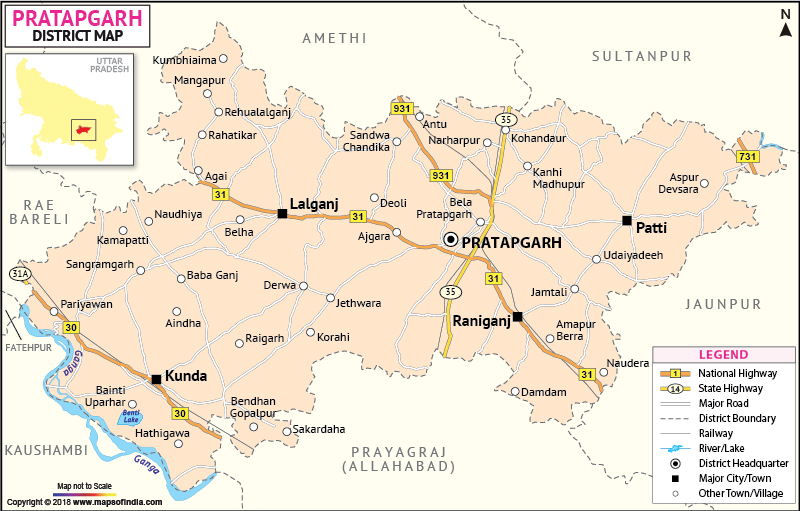
Recently, the benefits of Amla, a versatile fruit, have been discovered which has medicinal properties and its export is helping Pratapgarh flourish in its economy.
| Facts of Pratapgarh District | |
|---|---|
| State | Uttar Pradesh |
| District | Pratapgarh |
| District HQ | Pratapgarh |
| Population (2011) | 3209141 |
| Growth | 17.50% |
| Sex Ratio | 998 |
| Literacy | 70.09 |
| Area (km2) | 3717 |
| Density (/km2) | 854 |
| Tehsils | Kunda, Lalganj, Patti, Pratapgarh, Raniganj |
| Lok Sabha Constituencies | Pratapgarh |
| Assembly Constituencies | Babaganj, Biswanathganj, Kunda, Patti, Pratapgarh, Rampur Khas, Raniganj |
| Languages | Hindi, Awadhi, Urdu |
| Rivers | Sai, Ganga |
| Lat-Long | 25.903703,81.781425 |
| Travel Destinations | Belha Devi Temple, Aushaan Devi Temple, Baba Belkhar Nath Dham, Bhakti Dham Temple, Shri Ram Janki Hanuman Mandir, Maa Chauharjan (Barahi) Devi Temple, Kamakshi Devi Temple, Shani Dev Temple, Ram Janki Mandir, Old Hanuman Mandir, Ram Janki Mandir, Surya Mandir, Radha Krishna Temple, Inhan Devi Mandirkaali Maata Mandir etc. |
| Government Colleges/Universities | Hemwait Nandan Bahuguna Post Graduate Degree College, Mdpg College, P B College, Shiv Pati Devi Yamuna Prasad Mishra Balika Inter College, Govt Polytechnic, Dev Narayan Inter College, G. V. Inter College, S.B.P. Inter College, Shivram Intermediate College, Government Girls Inter College, M. P. S Intermediate College, R. S. B. Inter College etc. |
Last Updated on : January 14, 2026
