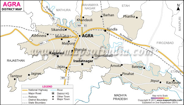
The economy of Agra district is based on agriculture, small scale industries and other small trades. The chief crops grown in the region are wheat, mustard, paddy, bajra, potato etc. There are more than 7200 Small Scale Industrial Units in the district which are engaged in the production of leather goods, handicrafts, zardozi, marble and stone carving and inlay work.
Agra district has many places of religions and historical value. The most important among them is Taj Mahal, one of the seven wonders of the world. Few other tourist attractions are Agra Fort, Itmad-ud-Daulah, Fatehpur Sikri, Sikandra and Radha Swami Samadhi.
| Facts of Agra District | |
|---|---|
| State | Uttar Pradesh |
| District | Agra |
| District HQ | Agra |
| Population (2011) | 4418797 |
| Growth | 22.05% |
| Sex Ratio | 868 |
| Literacy | 71.58 |
| Area (km2) | 4027 |
| Density (/km2) | 1084 |
| Tehsils | Etmadpur, Agra, Kiraoli, Kheragarh, Fatehabad and Bah |
| Lok Sabha Constituencies | 2-Agra, Fatehpur Sikri |
| Assembly Constituencies | Agra Cantt., Agra North, Agra Rural, Agra South, Bah, Etamdpur, Fatehabad, Fatehpur Sikri, Kheragarh |
| Languages | Hindi, Urdu including Braj Bhasha |
| Rivers | Yamuna |
| Lat-Long | 27.13248,78.013115 |
| Travel Destinations | Taj Mahal, Agra Fort, Chini Ka Rauza, Taj Nature Walk, Samadh Of Soamiji Maharaj, Ram Bagh, Mehtab Bagh, Itimad-Ud-Daula'S (Baby Taj), Sikandra, Mariyam'S Tomb, Jama Masjid, Mankameshwar Mandir, Rawali, Balkeshwar Mandir, Prithvinath Mandir, Rajeshwar Mandir, Guru Ka Tal Gurudwara, Cathedral St. Peter'S, St. Patricks, Baptist Church, Sai Ka Takia, Catholic Church, Digambar Jain Temple etc. |
| Government Colleges/Universities | Agra University, Sarojini Naidu Medical College, Agra College, St. John'S College, Raja Balwant Singh College, Dayalbagh Educational Institute, Anand Engineering College, Babu Mohan Lal Arya Smarak Engg. College, College Of Pharmacy, Anand College Of Pharmacy, M.D. College etc. |
Last Updated on: January 14, 2026
