| Click any neighbouring District / State and get the Detailed District Map |
 |
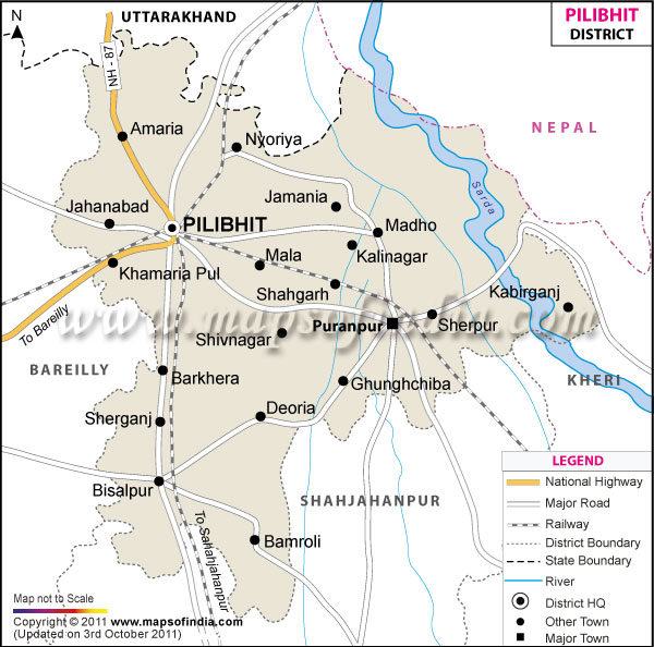
District Map of Pilibhit |
|
 |
|
 |
|
|
|
*The Map showing the National Highway, Major roads, other Roads, District Headquarter, Town, etc in the Pilibhit District, Uttar Pradesh |
Disclaimer
|
Close Disclaimer: All efforts have been made to make this image accurate. However Mapping Digiworld Pvt Ltd and its directors do not own any responsibility for the correctness or authenticity of the same. |
The district of Pilibhit lies from 28°6' to 28°53'North latitude and 79°57'to 80° 27' East longitudes. It covers an area of 3,504 sq.km, and is home to 2037225 denizens as of 2011 census.
Sugar industry and small-scale industries share the economy of the district.
Places to visit:
- Jama Masjid
- Gauri Shankar temple
- Hazrat Shah Dargah
- Methodist church
| Facts of Pilibhit District |
|---|
| State | Uttar Pradesh |
| District | Pilibhit |
| District HQ | Pilibhit |
| Population (2011) | 2031007 |
| Growth | 23.45% |
| Sex Ratio | 895 |
| Literacy | 61.47 |
| Area (km2) | 3499 |
| Density (/km2) | 567 |
| Tehsils | Bisalpur, Pilibhit, Puranpur |
| Lok Sabha Constituencies | Pilibhit |
| Assembly Constituencies | Barkhera, Bisalpur, Pilibhit, Puranpur |
| Languages | Hindi, Urdu, English, Punjabi |
| Rivers | --- |
| Lat-Long | 28.574874,80.01812 |
| Travel Destinations | Gauri Shankar Temple, Jama Masjid, Dargah Hazrat Shah Md. Sher Mian Ki, Chhathavi Padshahi Gurudwara, Raja Venu Ka Tila, Methodist Church, Raja Ji Temple, Ardhanarishwer Temple, Jaisantri Devi Temple, Gomat Taal, Devha-Ghaghra Sangum, Chuka Beach etc. |
| Government Colleges/Universities | Ramlubhai Sahani Govt. Girls Degree College, Govt. Degree College, Upadhi Mahavidhyalaya, Springdale College, L.H. Ayurvedic Medical College etc. |
Last Updated on : February 19, 2026
