| Click any neighbouring District / State and get the Detailed District Map |
 |
District Map of Lalitpur |
|
 |
|
 |
|
|
|
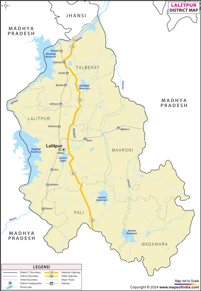
*The Map showing the National Highway, Major roads, other Roads, District Headquarter, Town, etc in the Lalitpur District, Uttar Pradesh |
Disclaimer
|
Close Disclaimer: All efforts have been made to make this image accurate. However Mapping Digiworld Pvt Ltd and its directors do not own any responsibility for the correctness or authenticity of the same. |
Lalitpur District of
Uttar Pradesh covers an expanse of 5039 sq. km area and encompassing the latitudinal parallels and longitudinal meridians of 24°11' to 25°13' North and 78°11?to79° East, respectively. Jhansi, Sagar, Tikamgarh, Chhatarapur, Shivpuri and Guna districts form Lalitpur?s geographic boundaries.
With a net population count of 12,18,002 Lalitpur District?s economy is distinctly agrarian.
Lalitpur District with its verdant terrains dotted with streaming rivers a sight to behold. The charm and serene tranquility of the district makes it an ideal weekend getaway for nature lovers.
| Facts of Lalitpur District |
|---|
| State | Uttar Pradesh |
| District | Lalitpur |
| District HQ | Lalitpur |
| Population (2011) | 1221592 |
| Growth | 24.94% |
| Sex Ratio | 906 |
| Literacy | 63.52 |
| Area (km) | 5039 |
| Density (/km) | 242 |
| Tehsils | Lalitpur, Mahroni, Talbehat |
| Lok Sabha Constituencies | Jhansi |
| Assembly Constituencies | 2-Lalitpur, Mehroni |
| Languages | Hindi, Urdu |
| Rivers | Jamani, Sajnam |
| Lat-Long | 24.65201,78.469448 |
| Travel Destinations | Deogarh, Neelkantheshwar Trimurti (Pali), Ranchourji, Pavagiri, Devmata, Machkud Ki Gufa, Tuvan Mandir, Ata Mandir, Kshetrapalji Temple etc. |
| Government Colleges/Universities | Sudarshan Degree College, Pahalvan Gurudeen Mahila Mahavidyalya, Nehru Maha Vidyalaya, Government Degree College, Pandit Deendayal Upadhaya Government College, Nagar Palika Girls College etc. |
Last Updated on : January 14, 2026
