|
||||||||||
| ||||||||||
|





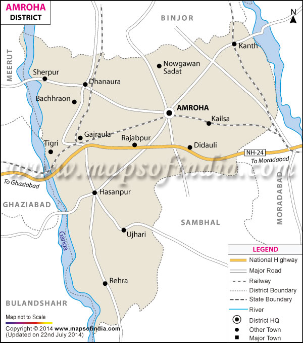
| *The Map showing the National Highway, Major roads, other Roads, District Headquarter, Town, etc in the Amroha District, Uttar Pradesh |
Named after the eminent social worker and reformer Jyotiba Phule, the district of Jyotiba Phule Nagar falls under the state of Uttar Pradesh.
The geographical area that the district covers is 2470 Sq. Km. The global location of Jyotiba Phule Nagar lies between 28° 54' and 39° 6' north latitudes and between 78° 28' and 78° 39' east longitudes.
Agriculture is the pre-dominant occupation in the district. Besides crop-growing, cottage industry is also an important source of revenue in Jyotiba Phule Nagar.
Some of the tourist destinations which are situated in the district or nearby it are Vasudev Mandir and Tulsi Park, Nasiruddin Sahib ki Majaar, Gajraula and Tigri.
| Facts of Jyotiba Phule Nagar District | |
|---|---|
| State | Uttar Pradesh |
| District | Jyotiba Phule Nagar |
| District HQ | Amroha |
| Population (2011) | 1840221 |
| Growth | 22.76% |
| Sex Ratio | 910 |
| Literacy | 63.84 |
| Area (km2) | 2321 |
| Density (/km2) | 818 |
| Tehsils | Amroha, Dhanaura, Hasanpur, Naugawan Sadat |
| Lok Sabha Constituencies | Amroha |
| Assembly Constituencies | Amroha, Dhanaura, Hasanpur, Naugawan Sadat |
| Languages | Hindi, Urdu |
| Rivers | Ganga |
| Lat-Long | 28.774882,78.337612 |
| Travel Destinations | Syed Husain Sharaf-Ud-Din Shahvilayat, Tigri Dham, Gajraula, and Amroha City |
| Major Educational Institutions | Govt. Rama Bai Ambedkar Degree College, Jagdish Saran Hindu College, B.I.Qureshi Degree College, Bhagirthi Degree College, Hashmi Girls Degree College, H.D. Degree College, M.Hussain Degree College, Nayab Abbasi Girls Degree College, Y.M.S. Degree College, H.M.U Hashmi College Of Law, Dns College Of Engineering And Technology, Maharaja Agrasen College Of Engineering And Technology etc. |
FAQs
Q1: Is Jyotiba Phule Nagar the same as Amroha?
Yes. Jyotiba Phule Nagar was officially renamed Amroha in 2012. Both names refer to the same district in western Uttar Pradesh.
Q2: Where is Jyotiba Phule Nagar (Amroha) located?
Amroha district is located in western Uttar Pradesh and is part of the Moradabad Division. It shares boundaries with Moradabad, Sambhal, Bijnor, Hapur, and Bulandshahr districts.
Q3: What does the Jyotiba Phule Nagar district map show?
The district map shows tehsil boundaries, major towns and villages, roads, railway lines, rivers, administrative headquarters, and neighbouring districts.
Q4: What are the tehsils in Amroha district?
Amroha district has four tehsils: Amroha, Dhanaura, Hasanpur, and Naugawan Sadat.
Q5: What is Amroha district famous for?
Amroha is known for its mango orchards, traditional dholak manufacturing, fertile agricultural land, and religious sites such as Tigri Dham.
Q6: Which river flows through Amroha district?
The Ganga River forms part of the western boundary of Amroha district and plays an important role in its agriculture.
Q7: What is the district headquarters of Jyotiba Phule Nagar?
The district headquarters is Amroha city, which is also the administrative and commercial centre of the district.
Last Updated on : July 13, 2026
