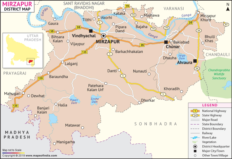
The Census Report, 2001 states the population of Mirzapur is 1657140. The district is supported by an agrarian economic backbone.
Tourism is a core revenue-generating sector of Mirzapur. Apart from the verdant topography and charming natural sites the other significant religious sanctums of Mirzapur include:
- Chunar
- VIindhachal
- Tarakeswar Mahadev
- Punyajala River
- Nagkund
- Maha Trikon
- Astabhuja Devi
- Sita Kund and
- Kantit Sharif
| Facts of Mirzapur District | |
|---|---|
| State | Uttar Pradesh |
| District | Mirzapur |
| District HQ | Mirzapur |
| Population (2011) | 2496970 |
| Growth | 18.00% |
| Sex Ratio | 903 |
| Literacy | 68.48 |
| Area (km2) | 4522 |
| Density (/km2) | 561 |
| Tehsils | Chunar, Lalganj, Marihan, Mirzapur |
| Lok Sabha Constituencies | Mirzapur |
| Assembly Constituencies | Chhanbey, Chunar, Majhawan, Marihan, Mirzapur |
| Languages | Hindi, Urdu, Agariya, Awadhi |
| Rivers | Ganga |
| Lat-Long | 25.01344,82.655239 |
| Travel Destinations | Chunar, Vindhachal Temple, Tarkeshwar Mahadev, Punyajala River, Nagkund, Maha Trikon, Astabhuja Devi Temple, Shivpur, Sita Kund, Kantit Sharif, Vindham Waterfall etc. |
| Government Colleges/Universities | Narottam Singh Padam Singh Government Degree College, Smt. Indira Gandhi Rajkiya Mahavidyalaya, K.B. P.G. College, G.D. Binnani P.G. College, Kamala Arya Kanya Mahavidyalaya, Vansthli Mahavidyalaya, Rajdeep Mahila Mahavidyalaya, Lalta Singh Rajkiya Mahila Mahila Mahavidyalaya, Ramkhelawan Singh P.G. College, Sri Bodhan Ram Mahavidyalaya, Narottam Singh Padam Singh Rajkiya Mahavidyalaya, Sri Krishna Degree College, Shivlok Srinet Mahavidyalaya, Vindyavasini Mahila Mahavidyalaya etc |
Last Updated on: February 19, 2026
